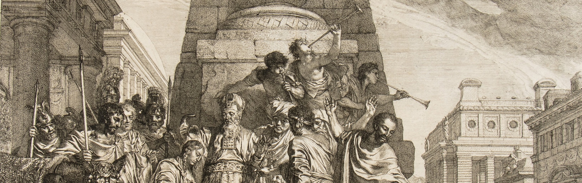
316
Live auction
Old and Modern Prints, Drawings and Maps
Palazzo Caetani Lovatelli - Piazza Lovatelli, 1 Rome, thu 14 November 2024
For information:
n.bukowska@bertolamifineart.com
n.bukowska@bertolamifineart.com
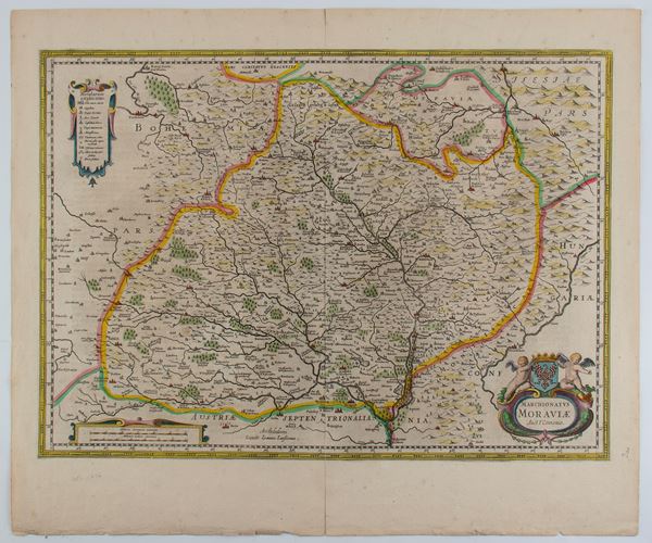
480
Peter Schenk
(1660 - 1713)
Marchionatus Moraviae Auct. I. Comenio
Amsterdam, circa 1700
Etching and engraving, 495 x 592 mm. Map of the territories of Moravia, today the eastern part of the Czech Republic, [..]
480
Peter Schenk
(1660 - 1713)
Marchionatus Moraviae Auct. I. Comenio
Amsterdam, circa 1700
Etching and engraving, 495 x 592 mm. Map of the territories of Moravia, today the eastern part of the Czech Republic, [..]
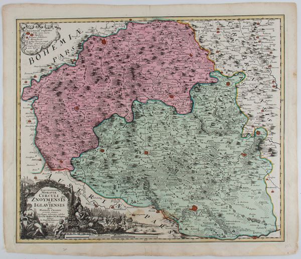
481
Johann Baptist Homann
(1664 - 1724)
Marchionatus Moraviae circuli Znoymensis et Iglaviensis
Nuremberg, 1750
Etching and engraving, 543 x 637 mm. Map of Znaim, Moravian region, southern Czech Republic, by Johann Christoph [..]
481
Johann Baptist Homann
(1664 - 1724)
Marchionatus Moraviae circuli Znoymensis et Iglaviensis
Nuremberg, 1750
Etching and engraving, 543 x 637 mm. Map of Znaim, Moravian region, southern Czech Republic, by Johann Christoph [..]
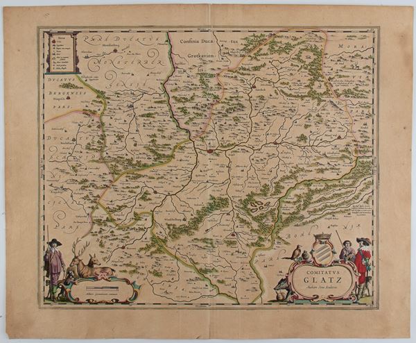
482
Comitatus Glatz. Authore Jona Sculteto
Etching and engraving, 490 x 600 mm. Map of the district of Glatz, a Prussian district in Silesia, which existed [..]
482
Comitatus Glatz. Authore Jona Sculteto
Etching and engraving, 490 x 600 mm. Map of the district of Glatz, a Prussian district in Silesia, which existed [..]
483
Willem Janszoon Blaeu
(1571 - 1638)
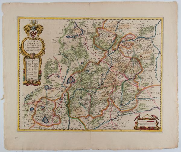
Ducatus Silesiae Glogani Vera Delineatio
Etching and engraving, 534 x 632 mm. Map of the municipality of Glogów, today in Lower Silesia in Poland, on [..]
483
Willem Janszoon Blaeu
(1571 - 1638)
Ducatus Silesiae Glogani Vera Delineatio
Etching and engraving, 534 x 632 mm. Map of the municipality of Glogów, today in Lower Silesia in Poland, on [..]
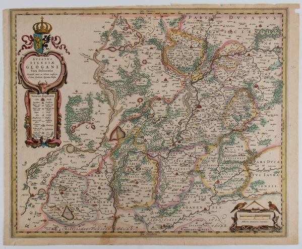
484
Willem Janszoon Blaeu
(1571 - 1638)
Ducatus Silesiae Glogani Vera Delineatio
Amsterdam, 1640
Etching and engraving, 430 x 535 mm. Map of the Duchy of Glogów, today in Silesia in Poland. Very nice colored [..]
484
Willem Janszoon Blaeu
(1571 - 1638)
Ducatus Silesiae Glogani Vera Delineatio
Amsterdam, 1640
Etching and engraving, 430 x 535 mm. Map of the Duchy of Glogów, today in Silesia in Poland. Very nice colored [..]
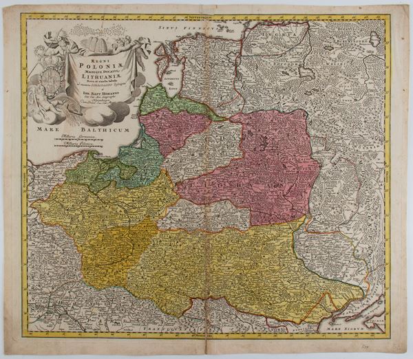
485
Johann Baptist Homann
(1664 - 1724)
Regni Poloniae Magnique Ducatus Lithuaniae Nova et Exacta Tabula
Nuremberg, 1729
Etching and engraving, 520 x 600 mm. Map of Poland and the Grand Duchy of Lithuania, extending from the Baltic [..]
485
Johann Baptist Homann
(1664 - 1724)
Regni Poloniae Magnique Ducatus Lithuaniae Nova et Exacta Tabula
Nuremberg, 1729
Etching and engraving, 520 x 600 mm. Map of Poland and the Grand Duchy of Lithuania, extending from the Baltic [..]
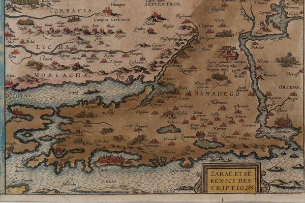
486
Abraham Ortelius
(1527 - 1598)
Zarae et Sebenici descriptio
Engraving, 150 x 240 mm (plate). Map of Croatia and Dalmatia taken from "Theatrum Orbis Terrarum". Fine, hand-colored [..]
486
Abraham Ortelius
(1527 - 1598)
Zarae et Sebenici descriptio
Engraving, 150 x 240 mm (plate). Map of Croatia and Dalmatia taken from "Theatrum Orbis Terrarum". Fine, hand-colored [..]
487
Pieter van der Aa
(1659 - 1733)
L'Europe Suivant les Nouvelles Observations...
1746
Etching and engraving, 242 x 305 mm (sheet). Map of Europe printed on laid paper with double watermark, trimmed [..]
487
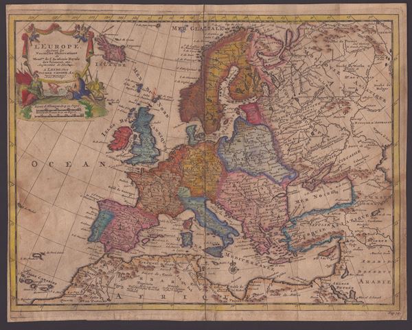
Pieter van der Aa
(1659 - 1733)
L'Europe Suivant les Nouvelles Observations...
1746
Etching and engraving, 242 x 305 mm (sheet). Map of Europe printed on laid paper with double watermark, trimmed [..]
![Guillaume de l'Isle (1675-1726) - Carte d'Europe dressée pour l'usage du Roy [sic] sur les itinéraires anciens et modernes et sur les routiers de mer assujettis aux observations astronomiques](https://api.bertolamifineart.com/api/lotto/immagine/117991/0/600.jpg)
488
Guillaume de l'Isle (1675-1726)
Carte d'Europe dressée pour l'usage du Roy [sic] sur les itinéraires anciens et modernes et sur les routiers de mer assujettis aux observations astronomiques
1782
Etching and engraving, 500 x 625 mm (plate), 530 x 725 mm (sheet). Map of Europe printed on laid paper with [..]
488
Guillaume de l'Isle (1675-1726)
Carte d'Europe dressée pour l'usage du Roy [sic] sur les itinéraires anciens et modernes et sur les [..]
1782
Etching and engraving, 500 x 625 mm (plate), 530 x 725 mm (sheet). Map of Europe printed on laid paper with [..]
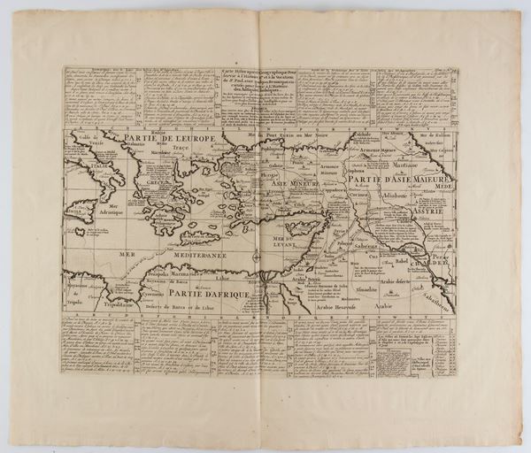
489
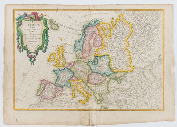
Jean Robert Janvier
(1776)
L'Europe divisée en ses principaux Etats
1782
Etching and engraving, 360 x 508 mm. Map of Europe printed on laid paper without watermark, with preserved margins [..]
489
Jean Robert Janvier
(1776)
L'Europe divisée en ses principaux Etats
1782
Etching and engraving, 360 x 508 mm. Map of Europe printed on laid paper without watermark, with preserved margins [..]
490
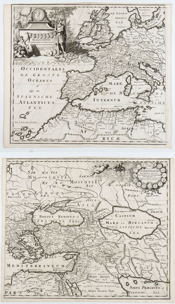
François Halma
(1653 - 1722)
Romani Imperii Occidentalis et Orientalis Decriptio Geographica Auct
1700 approx.
Printed on two sheets yet to be joined. Engraving and etching, 390 x 452 mm (each sheet). Map of the Roman Empire, [..]
490
François Halma
(1653 - 1722)
Romani Imperii Occidentalis et Orientalis Decriptio Geographica Auct
1700 approx.
Printed on two sheets yet to be joined. Engraving and etching, 390 x 452 mm (each sheet). Map of the Roman Empire, [..]
491
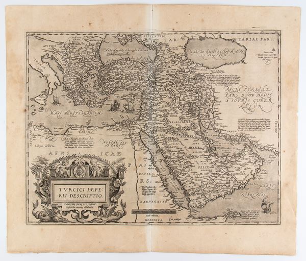
Abraham Ortelius
(1527 - 1598)
Turcici Imperii Descriptio
Engraving and etching, 482 x 563 mm (sheet). Map of the Middle East from the Latin edition of Ortelius' Theatrum [..]
491
Abraham Ortelius
(1527 - 1598)
Turcici Imperii Descriptio
Engraving and etching, 482 x 563 mm (sheet). Map of the Middle East from the Latin edition of Ortelius' Theatrum [..]
492
Reinier Ottens
(1698 - 1750)
Versus Chersonesi Tauricae Seu Crimeae Conspectus...
Amsterdam, 1737
Etching and engraving, 536 x 700 mm. Map of Crimea with surrounding areas during the Turkish-Austrian War (1736-1739). [..]
492
Reinier Ottens
(1698 - 1750)
Versus Chersonesi Tauricae Seu Crimeae Conspectus...
Amsterdam, 1737
Etching and engraving, 536 x 700 mm. Map of Crimea with surrounding areas during the Turkish-Austrian War (1736-1739). [..]
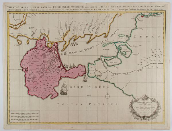
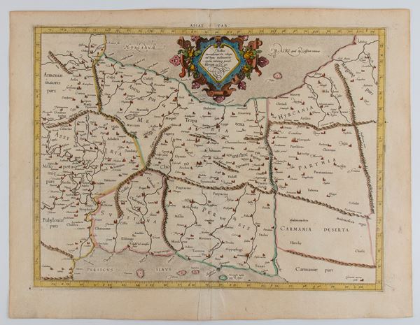
493
Gerardus Mercator
(1512 - 1594)
ASIAE TAB II
Etching and engraving, 410 x 535 mm (sheet). Map of the territories of present-day Armenia, Georgia, eastern Turkey [..]
493
Gerardus Mercator
(1512 - 1594)
ASIAE TAB II
Etching and engraving, 410 x 535 mm (sheet). Map of the territories of present-day Armenia, Georgia, eastern Turkey [..]
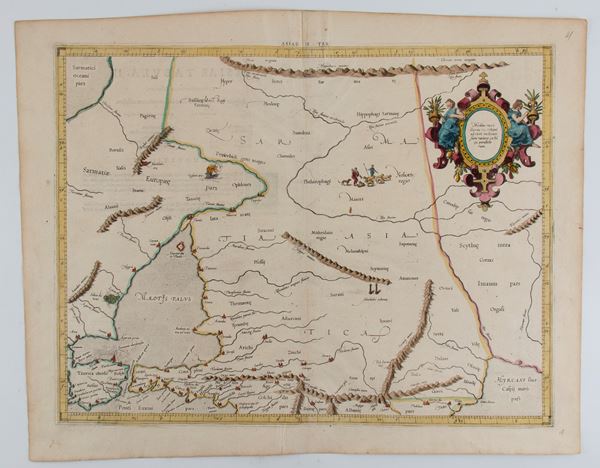
494
Gerardus Mercator
(1512 - 1594)
ASIAE V TAB
Etching and engraving, 410 x 535 mm (sheet). Map of the present territories of Iran and Iraq. Fine impression [..]
494
Gerardus Mercator
(1512 - 1594)
ASIAE V TAB
Etching and engraving, 410 x 535 mm (sheet). Map of the present territories of Iran and Iraq. Fine impression [..]
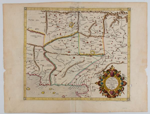
495
Gerardus Mercator
(1512 - 1594)
ASIAE IX TAB
1584
Etching and engraving, 410 x 535 mm (sheet). Beautiful map of the present territories of Pakistan, Afghanistan [..]
495
Gerardus Mercator
(1512 - 1594)
ASIAE IX TAB
1584
Etching and engraving, 410 x 535 mm (sheet). Beautiful map of the present territories of Pakistan, Afghanistan [..]
496
Gerardus Mercator
(1512 - 1594)
ASIAE X TAB
Etching and engraving, 410 x 535 mm (sheet). Map of the present territory of India. Fine impression with [..]
496
Gerardus Mercator
(1512 - 1594)
ASIAE X TAB
Etching and engraving, 410 x 535 mm (sheet). Map of the present territory of India. Fine impression with [..]
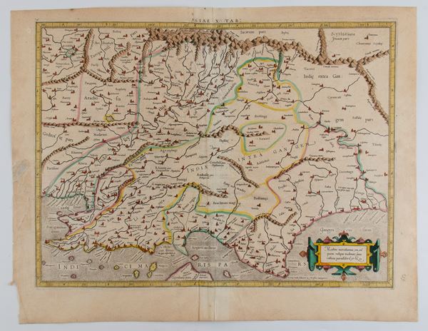
497
Johann Baptist Homann
(1664 - 1724)
Provinciarum Persicarum Kilaniae nempe Chirvaniae Dagestaniae
Etching and engraving, 517 x 627 mm (sheet). Map showing parts of present-day Georgia, Armenia, Dagestan, Azerbaijan [..]
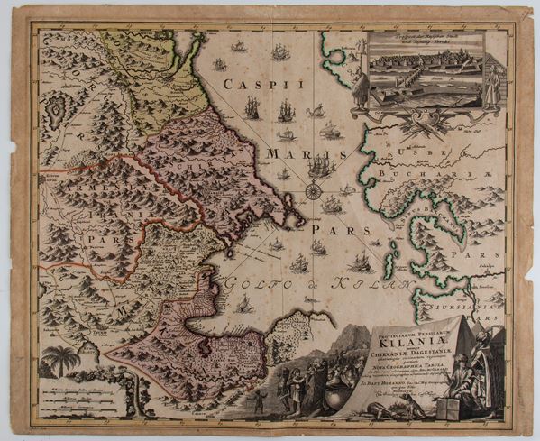
497
Johann Baptist Homann
(1664 - 1724)
Provinciarum Persicarum Kilaniae nempe Chirvaniae Dagestaniae
Etching and engraving, 517 x 627 mm (sheet). Map showing parts of present-day Georgia, Armenia, Dagestan, Azerbaijan [..]
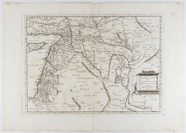
498
Philippe de La Rue
Assyria vetus divisa in Syriam, Messopotamiam, Babyloniam, et Assyriam
1695
Etching and engraving, 500 x 700 mm. Later edition of the train map of historical Assyria (now Israel, Lebanon, [..]
498
Philippe de La Rue
Assyria vetus divisa in Syriam, Messopotamiam, Babyloniam, et Assyriam
1695
Etching and engraving, 500 x 700 mm. Later edition of the train map of historical Assyria (now Israel, Lebanon, [..]
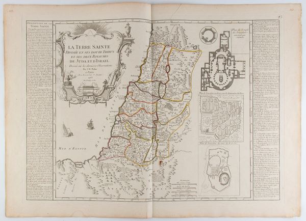
499
Jean-Baptiste Nolin
(1657 - 1725)
La Terre Sainte divisée en ses douze tribus et ses deux royaumes de Juda et d'Israël
1785
Etching and engraving, 553 x 768 mm. Historical map of the Holy Land, corresponding to the current territories [..]
499
Jean-Baptiste Nolin
(1657 - 1725)
La Terre Sainte divisée en ses douze tribus et ses deux royaumes de Juda et d'Israël
1785
Etching and engraving, 553 x 768 mm. Historical map of the Holy Land, corresponding to the current territories [..]
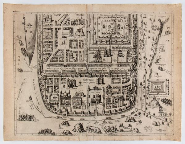
500
City of Jerusalem
Engraving and etching, 414 x 537 mm. Ancient plan of the City of Jerusalem. Copy printed on laid paper, with [..]
500
City of Jerusalem
Engraving and etching, 414 x 537 mm. Ancient plan of the City of Jerusalem. Copy printed on laid paper, with [..]
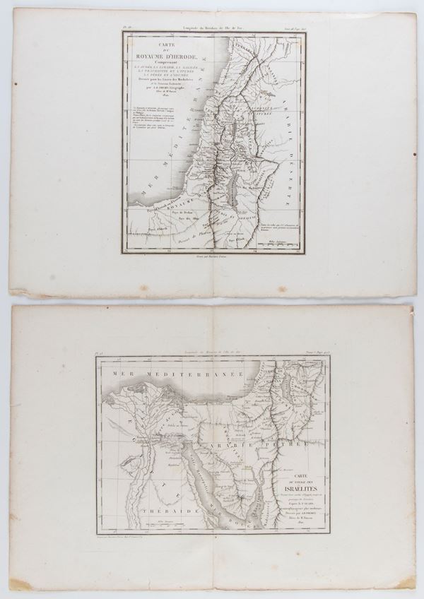
501
Antoine Rémy Frémin
Carte du voyage des Israelites | Carte du royaume d'Hérode
1820-1822
Etching and engraving, 283 x 400 mm (each sheet). Lot of two maps corresponding to the current territories of [..]
501
Antoine Rémy Frémin
Carte du voyage des Israelites | Carte du royaume d'Hérode
1820-1822
Etching and engraving, 283 x 400 mm (each sheet). Lot of two maps corresponding to the current territories of [..]
502
Henri Abraham Chatelain
(1684 - 1743)
Chaine de L'Histoire Sacree | Carte pour conduire à l'intelligence de l'histoire sacrée... | Carte Historique ... la vocation de St. Paul | Epoques Anciennes depuis le Deluge jusqu'a la Vocation d'Abraham
Lot of four prints: Chaine de L'Histoire Sacree: Chain De L'Histoire Prophane Cards to lead to the intelligence [..]
502
Henri Abraham Chatelain
(1684 - 1743)
Chaine de L'Histoire Sacree | Carte pour conduire à l'intelligence de l'histoire sacrée... | Carte Historique [..]
Lot of four prints: Chaine de L'Histoire Sacree: Chain De L'Histoire Prophane Cards to lead to the intelligence [..]
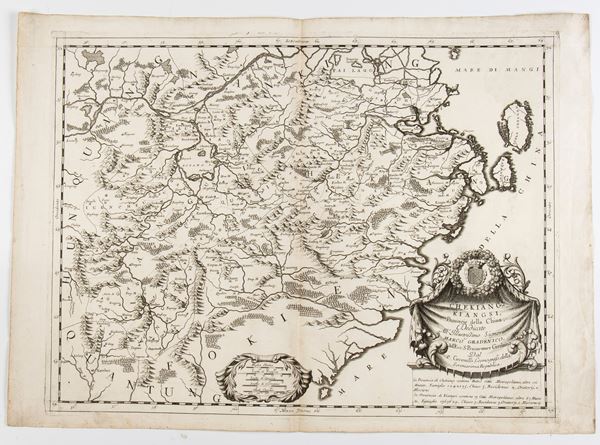
503
Vincenzo Maria Coronelli
(1650 - 1718)
Chekiang, and Kiangsi, Provinces of China...
Engraving and etching, 495 x 700 mm. Map of China with the provinces of Zhejiang and Jiangxi A fine example [..]
503
Vincenzo Maria Coronelli
(1650 - 1718)
Chekiang, and Kiangsi, Provinces of China...
Engraving and etching, 495 x 700 mm. Map of China with the provinces of Zhejiang and Jiangxi A fine example [..]
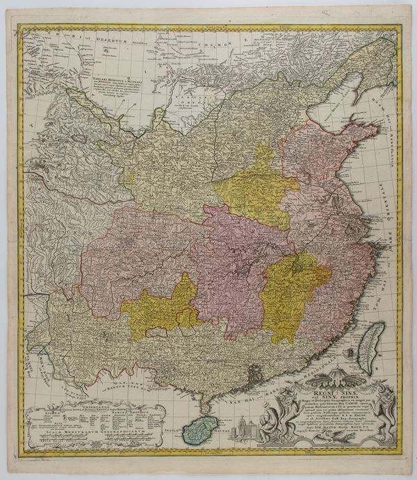
504
Eredi Johann Baptist Homann
Regni Sinae vel Sinae Propriae Mappa et Descriptio
Etching and engraving, 627 x 550 mm. Detailed map of China, showing the territory from the Gobi Desert to the [..]
504
Eredi Johann Baptist Homann
Regni Sinae vel Sinae Propriae Mappa et Descriptio
Etching and engraving, 627 x 550 mm. Detailed map of China, showing the territory from the Gobi Desert to the [..]
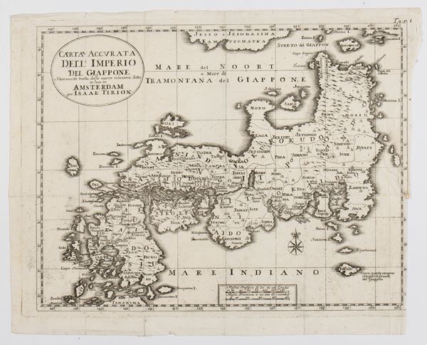
505
Isaak Tirion
(Utrecht, 1705 - Amsterdam, 1765)
Carta Accurata dell' Imperio del Giappone
Engraving and etching, 280 x 350 mm. Very nice impression on thin laid paper with watermark. In very good condition, [..]
505
Isaak Tirion
(Utrecht, 1705 - Amsterdam, 1765)
Carta Accurata dell' Imperio del Giappone
Engraving and etching, 280 x 350 mm. Very nice impression on thin laid paper with watermark. In very good condition, [..]
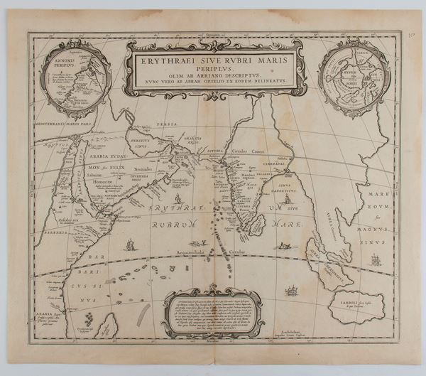
506
Johannes Janssonius
(1588 - 1664)
Erythraei Sive Rubri Maris Periplus
Amsterdam, 1658
Etching and engraving, 448 x 523 mm. Map of the Indian Ocean, known in antiquity as the Erythraean Sea. Nice [..]
506
Johannes Janssonius
(1588 - 1664)
Erythraei Sive Rubri Maris Periplus
Amsterdam, 1658
Etching and engraving, 448 x 523 mm. Map of the Indian Ocean, known in antiquity as the Erythraean Sea. Nice [..]
507
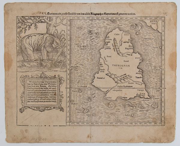
Sebastian Münster
(Ingelheim, 1488 - Basilea, 1552)
Taprobana Island (Sri Lanka)
1574
Woodcut, 322 x 392 mm (sheet). Map of Taprobana, the name by which the ancient Greeks identified the island of [..]
507
Sebastian Münster
(Ingelheim, 1488 - Basilea, 1552)
Taprobana Island (Sri Lanka)
1574
Woodcut, 322 x 392 mm (sheet). Map of Taprobana, the name by which the ancient Greeks identified the island of [..]
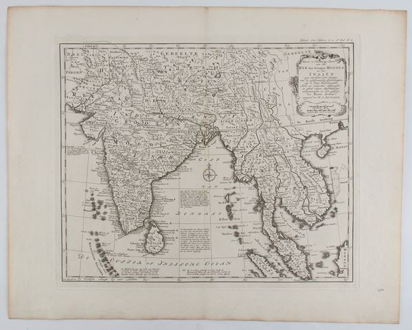
508
Nieuwe en Naukeurige Kaart van Het Ryk des Grooten Mogols en der Indien
Amsterdam, 1785
Engraving and etching, 447 x 563 mm. Dutch edition of the map of India and the Maldives. Fine impression [..]
508
Nieuwe en Naukeurige Kaart van Het Ryk des Grooten Mogols en der Indien
Amsterdam, 1785
Engraving and etching, 447 x 563 mm. Dutch edition of the map of India and the Maldives. Fine impression [..]
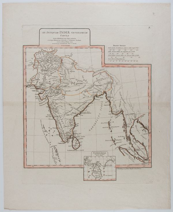
509
Jean-Baptiste d'Anville
(1697 - 1782)
Ad Antiquam Indiae Geographiam Tabula
Paris, 1765
Etching and engraving, 608 x 490 mm. Map of India, printed on laid paper with watermark and hand-colored. With [..]
509
Jean-Baptiste d'Anville
(1697 - 1782)
Ad Antiquam Indiae Geographiam Tabula
Paris, 1765
Etching and engraving, 608 x 490 mm. Map of India, printed on laid paper with watermark and hand-colored. With [..]

510
Gerardus Mercator
(1512 - 1594)
Africa Table I and Table III
Etching and engraving, approx. 410 x 510 mm each sheet. Lot of two maps of Africa by Mercator, based on the work [..]
510
Gerardus Mercator
(1512 - 1594)
Africa Table I and Table III
Etching and engraving, approx. 410 x 510 mm each sheet. Lot of two maps of Africa by Mercator, based on the work [..]
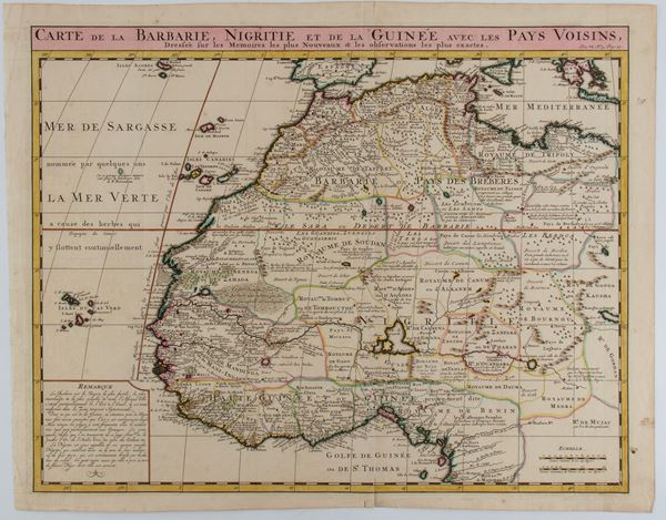
511
Henri Abraham Chatelain
(1684 - 1743)
Carte de la Barbarie Nigritie et de la Guinee avec les Pays Voisins
Etching and engraving, 435 x 550 mm (sheet). Map of North-West Africa, based on De L'Isle's map, from "Atlas Historique". [..]
511
Henri Abraham Chatelain
(1684 - 1743)
Carte de la Barbarie Nigritie et de la Guinee avec les Pays Voisins
Etching and engraving, 435 x 550 mm (sheet). Map of North-West Africa, based on De L'Isle's map, from "Atlas Historique". [..]
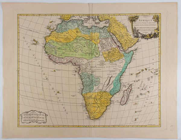
512
Robert de Vaugondy
(1688 - 1766)
L'Afrique dressée sur les relations les plus récentes
1756
Engraving and etching, 553 x 710 mm (sheet). Detailed map of Africa, published in Paris by De Vaugondy in his [..]
512
Robert de Vaugondy
(1688 - 1766)
L'Afrique dressée sur les relations les plus récentes
1756
Engraving and etching, 553 x 710 mm (sheet). Detailed map of Africa, published in Paris by De Vaugondy in his [..]
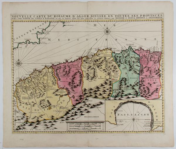
513
Reinier Ottens
(1698 - 1750)
Nouvelle carte du roiaume d'Alger divisée en toutes ses provinces
Amsterdam, 1780
Etching and engraving, 533 x 624 mm. Map of the North African coast with the territories of present-day Morocco [..]
513
Reinier Ottens
(1698 - 1750)
Nouvelle carte du roiaume d'Alger divisée en toutes ses provinces
Amsterdam, 1780
Etching and engraving, 533 x 624 mm. Map of the North African coast with the territories of present-day Morocco [..]
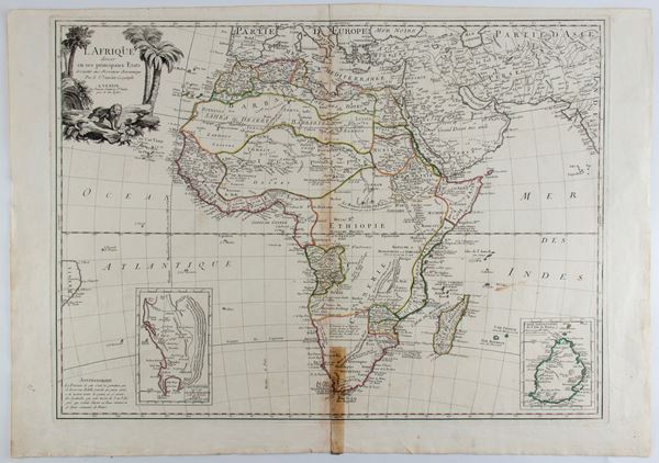
514
Jean Robert Janvier
(1776)
L'Afrique divisée en ses principaux Etats
Etching and engraving, 530 x 750 mm. Map of Africa, published in Venice by Santini. Fine impression printed [..]
514
Jean Robert Janvier
(1776)
L'Afrique divisée en ses principaux Etats
Etching and engraving, 530 x 750 mm. Map of Africa, published in Venice by Santini. Fine impression printed [..]
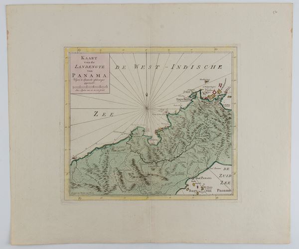
515
Isaak Tirion
(Utrecht, 1705 - Amsterdam, 1765)
Kaart van de landengte van Panama
1745 approx.
Etching and engraving, 420 x 492 mm. Map of Panama from "Nieuwe en beknopte hand-atlas" Fine example with beautiful [..]
515
Isaak Tirion
(Utrecht, 1705 - Amsterdam, 1765)
Kaart van de landengte van Panama
1745 approx.
Etching and engraving, 420 x 492 mm. Map of Panama from "Nieuwe en beknopte hand-atlas" Fine example with beautiful [..]
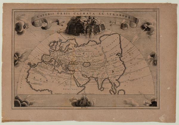
516
Christoph Cellarius
(1634 - 1707)
Veteris Orbis Climata ex Strabone
Etching and engraving, 255 x 375 mm. World map taken from "Notitia orbis antiqui sive geographia plenior" Burnished [..]
516
Christoph Cellarius
(1634 - 1707)
Veteris Orbis Climata ex Strabone
Etching and engraving, 255 x 375 mm. World map taken from "Notitia orbis antiqui sive geographia plenior" Burnished [..]
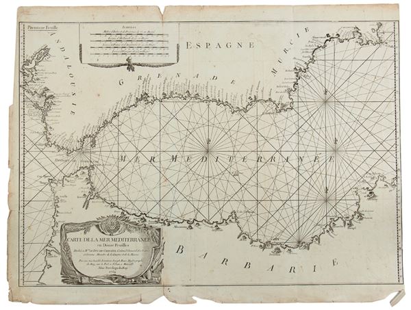
517
Joseph Roux
(1725 - 1793)
Carte de la Mer Méditerranée en douze feuilles
1764
Lot of 8 nautical charts from an atlas of 12 large plates of the Mediterranean, depicting ports, fortifications [..]
517
Joseph Roux
(1725 - 1793)
Carte de la Mer Méditerranée en douze feuilles
1764
Lot of 8 nautical charts from an atlas of 12 large plates of the Mediterranean, depicting ports, fortifications [..]
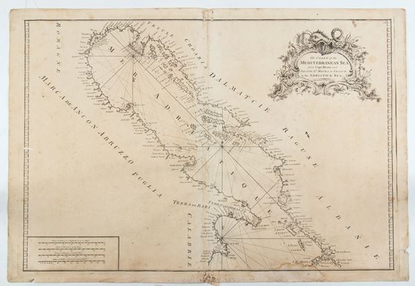
518
Mount & Page (Richard Mount (1654–1722) & Thomas Page (active 1700-1733))
The Coast of the Mediterranea Sea from Cape Ricuto and Island St. Maura to Venice in the Adriatick Sea
Nautical chart of the Italian and Croatian coast of the Mediterranean Sea, from Venice to Capo Rizzuto and from [..]
518
Mount & Page (Richard Mount (1654–1722) & Thomas Page (active 1700-1733))
The Coast of the Mediterranea Sea from Cape Ricuto and Island St. Maura to Venice in the Adriatick Se [..]
Nautical chart of the Italian and Croatian coast of the Mediterranean Sea, from Venice to Capo Rizzuto and from [..]
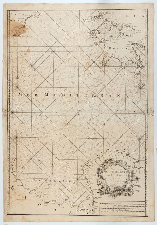
519
Mount & Page (Richard Mount (1654–1722) & Thomas Page (active 1700-1733))
The Coast of the Mediterranean Sea from Cape Spartevento, I. Cirico, and from Cape Mesurato to Cape Razatin
Nautical chart of the Mediterranean Sea with the Calabrian coast and part of the Greek coast, with the island [..]
519
Mount & Page (Richard Mount (1654–1722) & Thomas Page (active 1700-1733))
The Coast of the Mediterranean Sea from Cape Spartevento, I. Cirico, and from Cape Mesurato to Cape [..]
Nautical chart of the Mediterranean Sea with the Calabrian coast and part of the Greek coast, with the island [..]
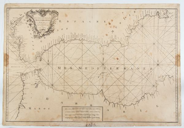
520
Mount & Page (Richard Mount (1654–1722) & Thomas Page (active 1700-1733))
A New Chart of the Coast of the Mediterranean sea from Cádiz and Cape Spartel to Cape Pallos and Cape Fallcon
Nautical chart of the Mediterranean Sea between the Spanish coast and the African coast, from Cadiz and Cape [..]
520
Mount & Page (Richard Mount (1654–1722) & Thomas Page (active 1700-1733))
A New Chart of the Coast of the Mediterranean sea from Cádiz and Cape Spartel to Cape Pallos and Cape [..]
Nautical chart of the Mediterranean Sea between the Spanish coast and the African coast, from Cadiz and Cape [..]
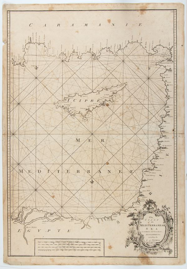
521
Mount & Page (Richard Mount (1654–1722) & Thomas Page (active 1700-1733))
The Coast of the Mediterranea Sea from Rusato and Gironda to Alexandreta including the I. of Cyprus
Nautical chart of the Mediterranean Sea with the Turkish, Israeli, Syrian and Egyptian coasts, and the island [..]
521
Mount & Page (Richard Mount (1654–1722) & Thomas Page (active 1700-1733))
The Coast of the Mediterranea Sea from Rusato and Gironda to Alexandreta including the I. of Cyprus
Nautical chart of the Mediterranean Sea with the Turkish, Israeli, Syrian and Egyptian coasts, and the island [..]
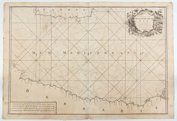
522
Mount & Page (Richard Mount (1654–1722) & Thomas Page (active 1700-1733))
The Coast of the Mediterranean Sea from Cape Razatin to Alexandria, with part of the Island of Candia
Nautical chart of the Mediterranean Sea between the African coast and the island of Crete. Etching and engraving, [..]
522
Mount & Page (Richard Mount (1654–1722) & Thomas Page (active 1700-1733))
The Coast of the Mediterranean Sea from Cape Razatin to Alexandria, with part of the Island of Candia [..]
Nautical chart of the Mediterranean Sea between the African coast and the island of Crete. Etching and engraving, [..]
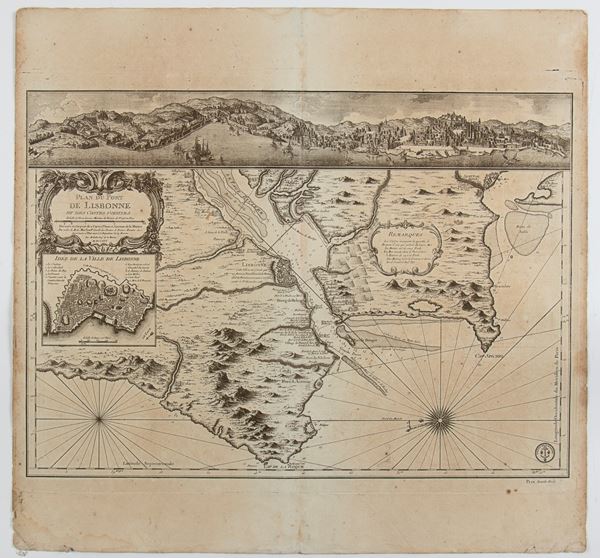
523
Jacques-Nicolas Bellin
(1703 - 1772)
Plan du Port de Lisbonne et des Costes voisines
Paris 1756
Map of the port of Lisbon and the surrounding coast, with a view of the city on the Tagus River in the upper [..]
523
Jacques-Nicolas Bellin
(1703 - 1772)
Plan du Port de Lisbonne et des Costes voisines
Paris 1756
Map of the port of Lisbon and the surrounding coast, with a view of the city on the Tagus River in the upper [..]
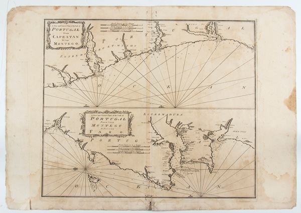
524
Mount & Page (Richard Mount (1654–1722) & Thomas Page (active 1700-1733))
A new and correct chart of the coast of Portugal from Cape Stan to Cape Montego | A new and correct chart of the coast of Portugal from Cape Montego to Pont de Faro
Map of the Portuguese coast from "A complete set of new charts on thirty-eight large plates containing an accurate [..]
524
Mount & Page (Richard Mount (1654–1722) & Thomas Page (active 1700-1733))
A new and correct chart of the coast of Portugal from Cape Stan to Cape Montego | A new and correct [..]
Map of the Portuguese coast from "A complete set of new charts on thirty-eight large plates containing an accurate [..]
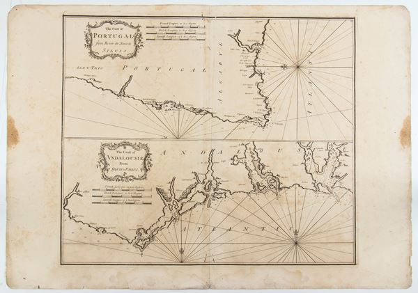
525
Mount & Page (Richard Mount (1654–1722) & Thomas Page (active 1700-1733))
The Coast of Portugal from River de Sinistra to Siluis | The Coast of Andalouisie from Siluis to Pallos
Map of the Portuguese coast taken from "A complete set of new charts on thirty-eight large plates containing [..]
525
Mount & Page (Richard Mount (1654–1722) & Thomas Page (active 1700-1733))
The Coast of Portugal from River de Sinistra to Siluis | The Coast of Andalouisie from Siluis to Pall [..]
Map of the Portuguese coast taken from "A complete set of new charts on thirty-eight large plates containing [..]
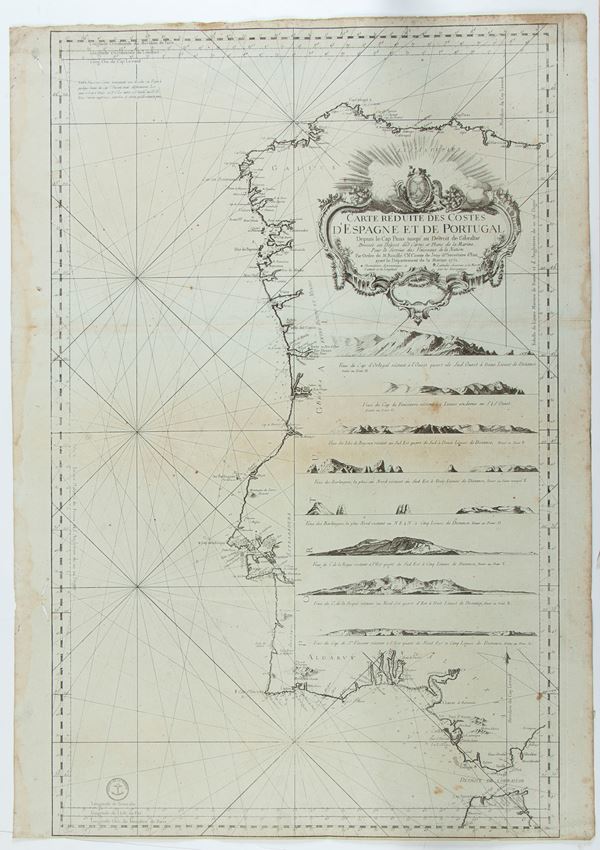
526
Jacques-Nicolas Bellin
(1703 - 1772)
Carte Reduite Des Costes D'Espagne et de Portugal
1751
Nautical chart of the coasts of Spain and Portugal. Etching and engraving, 890 x 630 mm. Printed on heavy laid [..]
526
Jacques-Nicolas Bellin
(1703 - 1772)
Carte Reduite Des Costes D'Espagne et de Portugal
1751
Nautical chart of the coasts of Spain and Portugal. Etching and engraving, 890 x 630 mm. Printed on heavy laid [..]
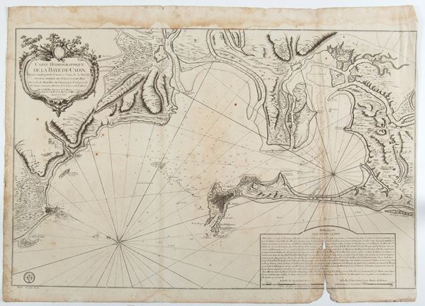
527
Jacques-Nicolas Bellin
(1703 - 1772)
Carte Hydrographique de la Baye de Cadix
London 17772
Hydrographic map of the Bay of Cadiz (Spain). Engraving and etching, 630 x 880 mm. Fine impression printed [..]
527
Jacques-Nicolas Bellin
(1703 - 1772)
Carte Hydrographique de la Baye de Cadix
London 17772
Hydrographic map of the Bay of Cadiz (Spain). Engraving and etching, 630 x 880 mm. Fine impression printed [..]
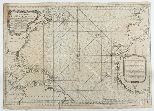
528
Jacques-Nicolas Bellin
(1703 - 1772)
Carte Reduite de L'Ocean-Occidental Comprenant les Cotes d'Europe et d'Afrique, depuis le 51 degre de Latitude Nord Jusqu'a l'Equateur et les Cotes
1766
Nautical map of the Atlantic Ocean, north of the equator, with the coast of North America, Florida and the coasts [..]
528
Jacques-Nicolas Bellin
(1703 - 1772)
Carte Reduite de L'Ocean-Occidental Comprenant les Cotes d'Europe et d'Afrique, depuis le 51 degre de [..]
1766
Nautical map of the Atlantic Ocean, north of the equator, with the coast of North America, Florida and the coasts [..]
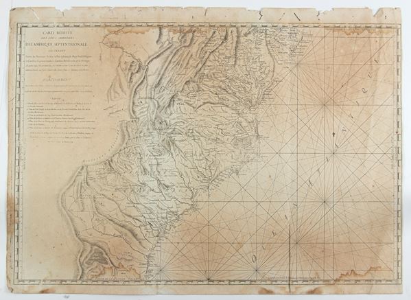
529
Antoine de Sartine
(1729 - 1801)
Carte Reduite des Cotes Orientales De L'Amerique Septentrionale Contentant Partie du Nouveau Jersey, la Pen-sylvanie, le Mary-land, la Virginie, la Caroline Septentrionale, la Caroline Meridionale et la Georgie...
Rome 1799
Italian edition of Sartine's map of the Atlantic coast, from the Chesapeake Bay and Delaware Bay to the mouth [..]
529
Antoine de Sartine
(1729 - 1801)
Carte Reduite des Cotes Orientales De L'Amerique Septentrionale Contentant Partie du Nouveau Jersey, [..]
Rome 1799
Italian edition of Sartine's map of the Atlantic coast, from the Chesapeake Bay and Delaware Bay to the mouth [..]
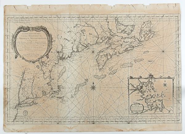
530
Jacques-Nicolas Bellin
(1703 - 1772)
Carte Reduite Des Costes Orientales De L'Amerique Septentrionale...contenant L'Isle Royale...La Nouvelle Angleterre et la Nouvelle Yorc
Paris 1757
Map of the East Coast of the United States, with New York, Connecticut, Rhode Island, Massachusetts, New Hampshire, [..]
530
Jacques-Nicolas Bellin
(1703 - 1772)
Carte Reduite Des Costes Orientales De L'Amerique Septentrionale...contenant L'Isle Royale...La Nouvelle [..]
Paris 1757
Map of the East Coast of the United States, with New York, Connecticut, Rhode Island, Massachusetts, New Hampshire, [..]
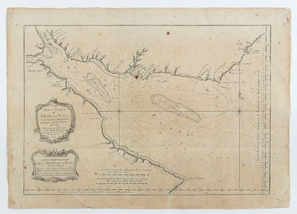
531
Jacques-Nicolas Bellin
(1703 - 1772)
Mapa y Planta del Rio de la Plata Leventada y Emendada novamente por los Pilotos del Rey . . . Carte Hydrographique de la Riviere de la Plata
Paris 1770
Map depicting the mouth of the Rio de la Plata between Argentina and Uruguay. Etching and engraving, 445 x [..]
531
Jacques-Nicolas Bellin
(1703 - 1772)
Mapa y Planta del Rio de la Plata Leventada y Emendada novamente por los Pilotos del Rey . . . Carte [..]
Paris 1770
Map depicting the mouth of the Rio de la Plata between Argentina and Uruguay. Etching and engraving, 445 x [..]
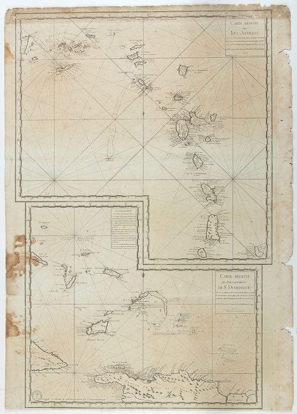
532
Carte Reduite des Isles Antilles | Carte Reduite des Debouquements de St Domingue
Paris 1775
Double map: the first of the Windward Islands from Puerto Rico to Barbados, the second showing the Turks and [..]
532
Carte Reduite des Isles Antilles | Carte Reduite des Debouquements de St Domingue
Paris 1775
Double map: the first of the Windward Islands from Puerto Rico to Barbados, the second showing the Turks and [..]
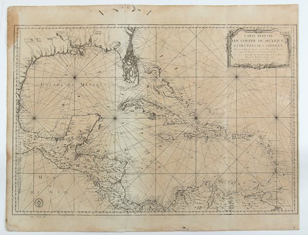
533
Jacques-Nicolas Bellin
(1703 - 1772)
Carte réduite du golphe du Mexique et des isles de l'Amérique
1774
Nautical chart of the Gulf Coast, showing the Gulf of Mexico, Guatemala, Nicaragua, Costa Rica and Panama. [..]
533
Jacques-Nicolas Bellin
(1703 - 1772)
Carte réduite du golphe du Mexique et des isles de l'Amérique
1774
Nautical chart of the Gulf Coast, showing the Gulf of Mexico, Guatemala, Nicaragua, Costa Rica and Panama. [..]